Tractatenblad van het Koninkrijk der Nederlanden
| Datum publicatie | Organisatie | Jaargang en nummer | Rubriek | Datum totstandkoming |
|---|---|---|---|---|
| Ministerie van Buitenlandse Zaken | Tractatenblad 2023, 66 | Verdrag |
U bent nu hier: Publicaties Officiële publicaties
Zoals vergunningen, bouwplannen en lokale regelgeving.
Adressen en contactpersonen van overheidsorganisaties.

5 (2023) Nr. 1
Verdrag tussen de regering van het Koninkrijk der Nederlanden en de regering van de Franse Republiek inzake de grensafbakening tussen het Koninkrijk der Nederlanden (Sint Maarten) en de Franse Republiek (Saint-Martin) (met bijlagen);
Belle Plaine / Belvédère, 26 mei 2023
Voor een overzicht van de verdragsgegevens, zie verdragsnummer 013951 in de Verdragenbank.
The government of the Kingdom of the Netherlands,
and
the government of the French Republic,
hereafter “the Parties”,
Reaffirming their commitment to the traditional relations of friendship and good neighbourliness between the Kingdom of the Netherlands and the French Republic in the Caribbean region;
Considering that it is necessary to delimit their shared boundary;
Having regard to the Treaty of Concordia (Sint Maarten) concluded on 23 March 1648;
Having regard to the United Nations Convention on the Law of the Sea, concluded at Montego Bay on 10 December 1982, to which the Kingdom of the Netherlands and the French Republic are Parties;
Considering the Agreement between the government of the Kingdom of the Netherlands and the government of the French Republic on Maritime Delimitations in the Caribbean region, signed at Philipsburg on 6 April 2016, in particular articles 3 and 4 thereof;
Have agreed as follows:
For the purposes of this Agreement, the terms below are defined as follows:
a) “Internal waters”: waters on the landward side of the baseline of the territorial sea.
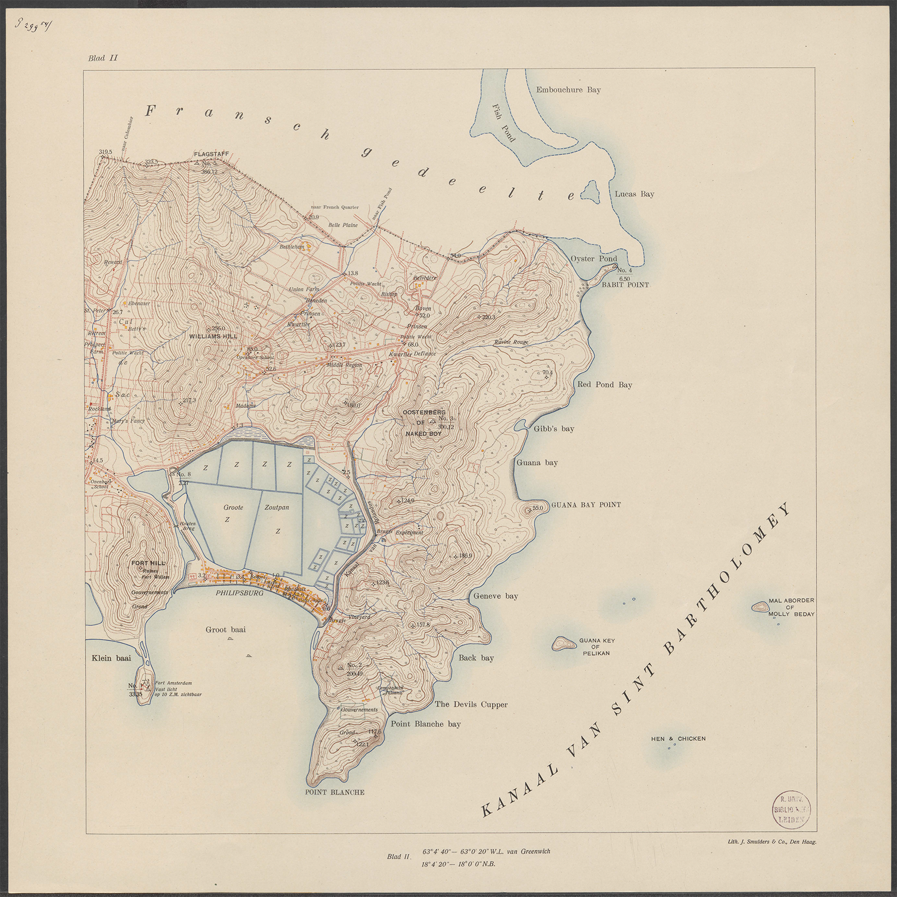
b) “Werbata map”: the map published in 1915 by J. Smulders & Co., based on the topographic surveys and work carried out by engineers Werbata and Jonckheer.
c) “Maritime delimitation agreement”: the Agreement of 6 April 2016 between the government of the Kingdom of the Netherlands and the government of the French Republic on Maritime Delimitations in the Caribbean region.
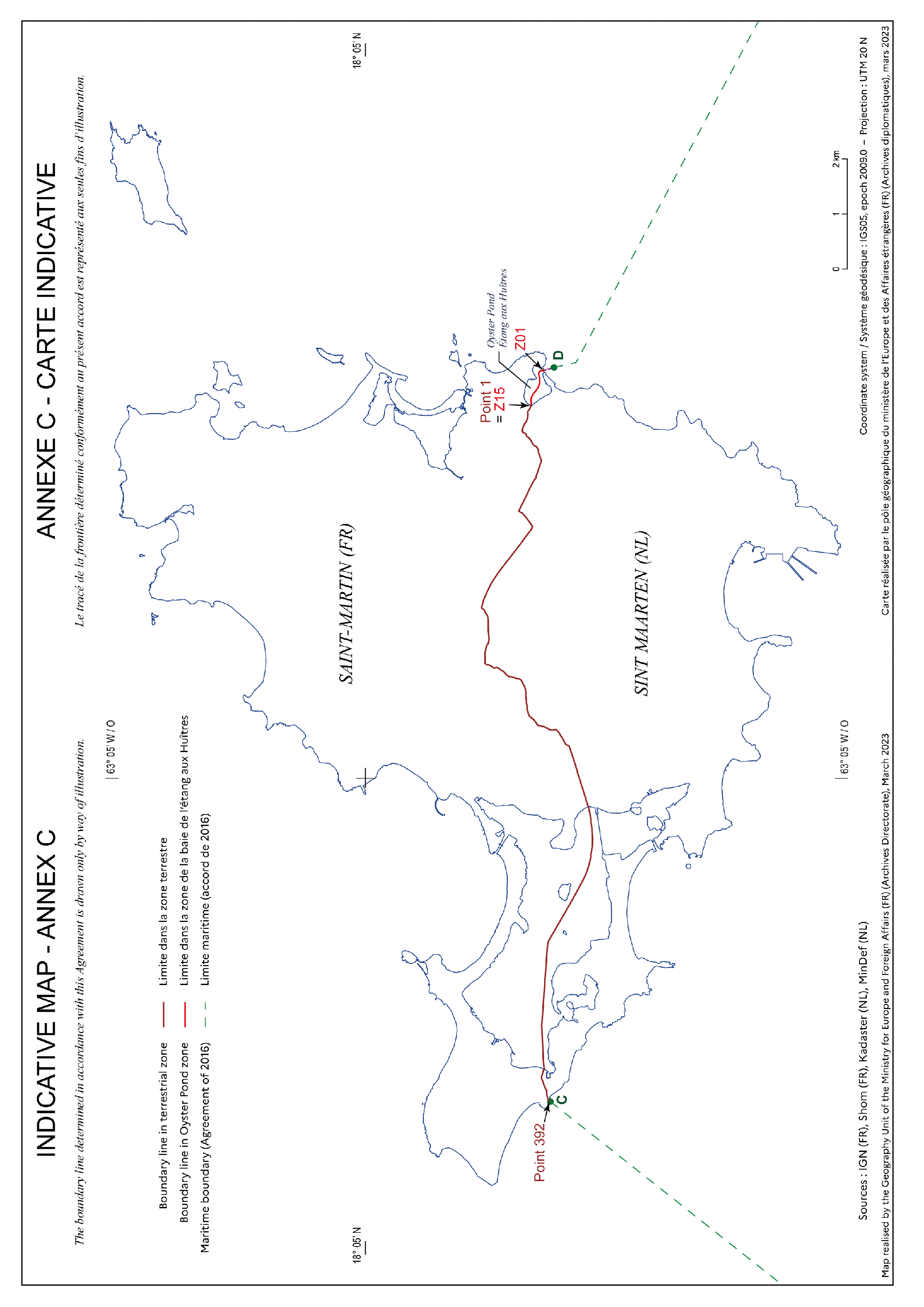
The object of this Agreement is to delimit the boundary line between the Kingdom of the Netherlands (Sint Maarten) and the French Republic (Saint-Martin), from the end of the eastern part (point D) to the end of the western part (point C) of the delimitation established in the maritime delimitation agreement.
3.1. The boundary line is determined by the numerical geographical coordinates indicated in Annex A to this Agreement. It runs in a straight (geodesic) line between two successive points.
3.2. Points C and D laid down in the maritime delimitation agreement are set out in Annex A and are linked to the ends of the boundary line defined in the first paragraph of this Article.
3.3. For the maritime boundary, the geographical coordinates of the points established in this Agreement are expressed in the geodetic reference system WGS 84 (World Geodetic System 1984), which in turn is aligned with the ITRS (International Terrestrial Reference System).
3.4. For the land boundary, the geographic coordinates of the points established in this Agreement are expressed in the ITRS (International Terrestrial Reference System).
3.5. The Committee established pursuant to Article 9, taking account of the Werbata map or, in relation to Oyster Pond, the principle of equidistance, may propose modifications to the numerical geographical coordinates set out in Annex A to the Parties. The Parties can, by mutual agreement, approve these proposals in accordance with the procedure laid down in Article 16.
4.1. The waters of Oyster Pond are designated internal waters.
4.2. The right of innocent passage is recognised and guaranteed to all ships, irrespective of nationality.
4.3. The Oyster Pond closing line is defined by a straight (geodesic) line linking the points designated by the geographical coordinates set out in Annex B.
5.1. In compliance with the legal and regulatory provisions in force on the territory of the parties concerned, the Parties shall mutually recognise and guarantee to vessels flying their flags in Oyster Pond and Simpson Bay Lagoon:
a) access
b) freedom of navigation
c) mooring
d) freedom to conduct artisanal fishing
5.2. Without prejudice to the provisions set out in Article 4, paragraph 2, the provisions established in Article 5, paragraph 1 do not apply to warships of the Parties and other government ships operated by one of the Parties for non-commercial purposes, for which cooperation is governed by separate arrangements or agreements.
6.1. The demarcation of the boundary established in this Agreement must be specified and maintained in such a manner that the boundary line is clearly determined and can be easily identified along its entire length.
6.2. The demarcation of the land boundary is established by way of physical features (walls or low walls, monuments, rivers, roads, ridge lines, etc.) that exist on the date this Agreement enters into force, described and listed at a later date by the Committee established pursuant to Article 9. This Committee has the power to establish new demarcation features or modify or remove existing ones, if it deems this to be necessary.
6.3. Each of the Parties, within the framework of its statutory, regulatory and administrative provisions, in particular for the part of the demarcation situated on its territory, shall take the necessary measures to ensure the monitoring and maintenance of the boundary demarcation and to prevent and, if necessary, suppress the destruction, deterioration and inappropriate use of physical demarcation features.
6.4. If the Committee established pursuant to Article 9 deems it necessary, a strip of land not exceeding 4 metres in width (2 metres on each side of the boundary) can be kept permanently cleared in order to ensure the boundary can be accessed, monitored and maintained.
6.5. The costs resulting from the demarcation and the maintenance of the boundary shall be shared equally between the Parties. However, when demarcation work is made necessary due to works that are the subject of a concession, the costs related to this work shall be borne by the concession holder.
6.6. The Parties accept that the equipment and materials needed to maintain the boundary shall freely enter into the territory of the other Party, on the understanding that, upon completion of the work, equipment, unused materials and means of transportation shall be returned to the territory of the Party where they originated.
6.7. The maintenance of immovable property belonging to public or private entities other than the Parties (such as monuments, walls, low walls and other artificial structures) retained as territorial demarcation features by the Parties remains the responsibility of the current owners of the immovable property. The owners are required to restore the aforementioned property to or keep it in a good state of repair, respect any technical requirements laid down by the Committee established pursuant to Article 9, grant competent agents of the Parties continued access to the demarcation features and the routes to access them, including by way of clearing them when the Committee established pursuant to Article 9 deems this necessary, and participate in or be represented during visits to the aforementioned features when required to do so by the competent agents. In the event of failure to comply, each Party can act on behalf of the owners in question and recover from them the costs incurred in so doing.
6.8. The provisions set out in paragraph 7 do not extend to new demarcation features that the Committee established pursuant to Article 9 may determine after this Agreement enters into force.
6.9. New physical demarcation features placed along the axis of the boundary are the joint property of both Parties. Other new physical demarcation features remain the property of the Party on whose territory they are located.
7.1. The Parties shall guarantee free access to thoroughfares, roads and paths that run along the boundary line.
7.2. Without prejudice to paragraph 1 of this Article, agents carrying out a service of general interest shall have right of access if access to the boundary requires the use of a private thoroughfare.
8.1. No new structures can be erected within 2 metres of either side of the boundary. Along watercourses and paths forming the boundary, this distance is measured from the banks and edges thereof.
8.2. The Parties can, by mutual agreement in the framework of the Committee established pursuant to Article 9, consent to derogations from the provisions set out in paragraph 1 of this Article in order to take account of special circumstances at the boundary, on condition that the authorised structures do not prevent access to or the maintenance or monitoring of the boundary.
8.3. The provisions set out in paragraph 1 of this Article do not apply to structures dedicated to official services of one of the Parties or public works that it has authorised.
8.4. Existing structures built in accordance with the conditions provided by the applicable regulations in the territory of each of the Parties shall be tolerated in accordance with acquired rights. If these structures are demolished or modified, their reconstruction or modification shall be authorised only if it is in conformity with the provisions set out in this Article, in accordance with the legislation and regulations of the Party concerned. The same applies to structures in a state of ruin.
9.1. In order to enable the implementation of this Agreement, a joint boundary monitoring and maintenance committee (“the Committee”) shall be established upon entry into force of this Agreement.
9.2. The Committee shall comprise three representatives of the Parties.
9.3. Each delegation can appoint the experts it deems necessary.
9.4. Each Party shall be responsible for covering the costs of its delegation to the Committee.
9.5. The Committee shall meet alternately in the Kingdom of the Netherlands and the French Republic, with the host Party acting as chair. The Committee shall meet at the request of either delegation, at least once a year.
9.6. The Committee shall take decisions unanimously. Issues on which no agreement can be reached within the Committee shall be submitted for consideration to the respective foreign ministries of the Parties, in order for them to endeavour to resolve these issues by mutual agreement.
9.7. The Committee may adopt its own rules of procedure.
9.8. The Committee shall be tasked with the following:
a) Proposing modifications to Annex A in accordance with Article 3, paragraph 5.
b) Establishing and updating a distribution plan for boundary maintenance and demarcation work, and ensuring the implementation thereof.
c) Adopting all the measures necessary to ensure that documentation relating to the position of physical demarcation features and the description and realisation of the boundary line is drawn up without delay, in particular in the zones where this is lacking, and ensuring this documentation is kept up to date.
d) Reviewing the reports provided for by Article 10, paragraph 7 and taking the appropriate measures in accordance with its remit.
e) Addressing any difficulties which could result from the application of the provisions of this Agreement and proposing measures to the Parties in order to resolve these difficulties.
9.9. The meetings of the Committee shall be the subject of official reports, done in two originals, one in French and one in English, intended for the Parties.
10.1. The maintenance, manufacture, installation, monitoring and replacement of physical demarcation features created by each of the Parties under this Agreement are assigned to a competent agent appointed by the respective Party.
10.2. The Parties shall share the names of their competent agents with one another.
10.3. The competent agents can, with a view to the implementation of this Agreement, freely cross the boundary, provided they carry an identity document recognised by both States.
10.4. The competent agents shall, during a joint inspection, draw up a summary of the work to be carried out in order to maintain or replace physical demarcation features; this summary must include an estimate of the costs relating to this work.
10.5. The competent agents shall, following agreement from the Committee referred to in Article 9, arrange for the execution of the works that are the responsibility of the Party under whose authority they fall or that that Party must carry out on behalf of the other Party. However, in exceptional circumstances, for work of a clearly urgent nature, the competent agents can, on their own initiative, take the necessary precautionary measures, provided that they inform the Committee of this as soon as possible.
10.6. The competent agents shall draw up an annual report on the work carried out to maintain or replace physical demarcation features; this report must set out the costs that relate to the work done.
10.7. Activities provided for in this Article shall be the subject of a report, done in two originals, one in French and one in English, signed by the competent agents of the Parties. This report shall be addressed to the Committee established pursuant to Article 9 and to the Parties.
11.1. The Parties shall guarantee to uphold rights acquired by natural and legal persons directly affected by the boundary delimitation, in accordance with the legal and regulatory provisions in force in the territory of the Parties concerned.
11.2. Properties, temporary occupancies or other particulars that are to be recorded in one or the other of the Parties' mortgage registers, land registers or other registers must, pursuant to the provisions of this Agreement, be registered with the competent authority within a period of two years following the entry into force of this Agreement.
11.3. Where appropriate, property shall be recorded in mortgage registers, land registers or other registers of the competent authority and removed from registers of the other Party.
11.4. The activities of natural and legal persons directly affected by the boundary delimitation can be continued in accordance with the legal and regulatory provisions in force in the territory of the Parties concerned.
12.1. In the twelve months following the entry into force of this Agreement, each of the Parties shall regularise, in so far as possible, the situations of natural and legal persons affected by this Agreement, and the administrative issues connected to the delimitation implemented under Article 3 of this Agreement.
12.2. Each of the Parties can refer any issue or situation under this article to the Committee established pursuant to Article 9.
13.1. The Parties recognise the need to conclude, in a cross-border framework agreement, cross-border cooperation arrangements in areas of common interest.
13.2. The Parties shall promote mechanisms that facilitate cross-border cooperation, in particular at local level.
Any dispute between the Parties concerning the interpretation or application of this Agreement shall be settled peacefully by consultation and negotiation, in accordance with international law.
This Agreement can be amended at any time by mutual written agreement between the Parties. Without prejudice to Article 16, any amendment shall enter into force in accordance with the provisions laid down in Article 17.
16.1. Annexes A and B form an integral part of this Agreement.
16.2. Annexes A and B to this Agreement can be modified by mutual agreement between the Parties through an exchange of diplomatic notes.
16.3. The boundary line determined in accordance with this Agreement is drawn by way of illustration on the map in Annex C of this Agreement.
16.4. For the purposes of the application of Article 3, paragraph 5, a certified copy of the Werbata map is appended to this Agreement as Annex D.
IN WITNESS WHEREOF, the undersigned, duly authorised by their respective governments, have signed this Agreement.
DONE at Belle Plaine / Belvédère, on May 26th 2023, in two originals, in the English and French language, both texts being equally authentic.
For the government of the Kingdom of the Netherlands, SILVERIA ELFRIEDA JACOBS
For the government of the French Republic, GÉRALD DARMANIN
Annex A: List of the numerical geographical coordinates of the boundary between the Kingdom of the Netherlands (Sint Maarten) and the French Republic (Saint-Martin).
Annex B: List of the numerical geographical coordinates of the closing line at Oyster Pond.
Annex C: Map showing the boundary line by way of illustration.
Annex D: Werbata map for the purposes of the application of Article 3, paragraph 5.
For the purposes of this Annex, the reference to the ITRS in Article 3 means that the geographical coordinates of the points are expressed in the geodetic reference frame IGS2005 (International GNSS Service 2005) epoch 2009.0.
DD: decimal degrees
DMS: degrees-minutes-seconds
|
Point |
Latitude (North) |
Longitude (West) |
|---|---|---|
|
Point D (DMS) |
18°03’ 08,00” |
-63°00’ 46,00” |
|
Point D (DD) |
18,052222 |
-63,012778 |
From point D of the maritime boundary agreed between the French Republic and the Kingdom of the Netherlands, the delimitation extends along a geodetic line to point Z01:
Decimal degrees
|
Point |
Latitude (North) |
Longitude (West) |
|---|---|---|
|
Z01 |
18,053935 |
-63,013297 |
|
Z02 |
18,054182 |
-63,013268 |
|
Z03 |
18,054543 |
-63,013407 |
|
Z04 |
18,054749 |
-63,013748 |
|
Z05 |
18,054691 |
-63,014179 |
|
Z06 |
18,054606 |
-63,014713 |
|
Z07 |
18,054572 |
-63,015265 |
|
Z08 |
18,054710 |
-63,015915 |
|
Z09 |
18,054959 |
-63,016419 |
|
Z10 |
18,055297 |
-63,016875 |
|
Z11 |
18,055744 |
-63,017472 |
|
Z12 |
18,055996 |
-63,018121 |
|
Z13 |
18,055997 |
-63,018617 |
|
Z14 |
18,055929 |
-63,019035 |
|
Z15 (=1) |
18,056027 |
-63,019351 |
Decimal degrees
|
Point |
Latitude (North) |
Longitude (West) |
|---|---|---|
|
1 (=Z15) |
18,056027 |
-63,019351 |
|
2 |
18,056154 |
-63,019814 |
|
3 |
18,056511 |
-63,020331 |
|
4 |
18,056511 |
-63,020362 |
|
5 |
18,056526 |
-63,020430 |
|
6 |
18,056522 |
-63,020514 |
|
7 |
18,056506 |
-63,020746 |
|
8 |
18,056501 |
-63,020806 |
|
9 |
18,056514 |
-63,021002 |
|
10 |
18,056526 |
-63,021129 |
|
11 |
18,056545 |
-63,021299 |
|
12 |
18,056582 |
-63,021472 |
|
13 |
18,056665 |
-63,021698 |
|
14 |
18,056660 |
-63,021704 |
|
15 |
18,056658 |
-63,021711 |
|
16 |
18,056658 |
-63,021723 |
|
17 |
18,056661 |
-63,021765 |
|
18 |
18,056668 |
-63,021815 |
|
19 |
18,056679 |
-63,021854 |
|
20 |
18,056701 |
-63,021907 |
|
21 |
18,056739 |
-63,021991 |
|
22 |
18,056779 |
-63,022077 |
|
23 |
18,056843 |
-63,022184 |
|
24 |
18,056873 |
-63,022250 |
|
25 |
18,056900 |
-63,022260 |
|
26 |
18,056921 |
-63,022274 |
|
27 |
18,056974 |
-63,022326 |
|
28 |
18,057032 |
-63,022415 |
|
29 |
18,057074 |
-63,022473 |
|
30 |
18,057113 |
-63,022557 |
|
31 |
18,057155 |
-63,022651 |
|
32 |
18,057206 |
-63,022775 |
|
33 |
18,057250 |
-63,022881 |
|
34 |
18,057269 |
-63,022926 |
|
35 |
18,057290 |
-63,022992 |
|
36 |
18,057312 |
-63,023090 |
|
37 |
18,057324 |
-63,023172 |
|
38 |
18,057341 |
-63,023259 |
|
39 |
18,057365 |
-63,023338 |
|
40 |
18,057385 |
-63,023380 |
|
41 |
18,057403 |
-63,023441 |
|
42 |
18,057414 |
-63,023502 |
|
43 |
18,057423 |
-63,023572 |
|
44 |
18,057427 |
-63,023640 |
|
45 |
18,057410 |
-63,023728 |
|
46 |
18,057376 |
-63,023825 |
|
47 |
18,057360 |
-63,023875 |
|
48 |
18,057333 |
-63,023918 |
|
49 |
18,057282 |
-63,023968 |
|
50 |
18,057229 |
-63,024006 |
|
51 |
18,057185 |
-63,024016 |
|
52 |
18,057094 |
-63,024036 |
|
53 |
18,057046 |
-63,024051 |
|
54 |
18,056981 |
-63,024085 |
|
55 |
18,056928 |
-63,024130 |
|
56 |
18,056886 |
-63,024178 |
|
57 |
18,056849 |
-63,024229 |
|
58 |
18,056824 |
-63,024260 |
|
59 |
18,056796 |
-63,024306 |
|
60 |
18,056777 |
-63,024359 |
|
61 |
18,056767 |
-63,024394 |
|
62 |
18,056761 |
-63,024426 |
|
63 |
18,056756 |
-63,024472 |
|
64 |
18,056751 |
-63,024492 |
|
65 |
18,056729 |
-63,024547 |
|
66 |
18,056703 |
-63,024592 |
|
67 |
18,056674 |
-63,024624 |
|
68 |
18,056608 |
-63,024678 |
|
69 |
18,056524 |
-63,024746 |
|
70 |
18,056464 |
-63,024792 |
|
71 |
18,056371 |
-63,024855 |
|
72 |
18,056357 |
-63,024875 |
|
73 |
18,056296 |
-63,024942 |
|
74 |
18,056247 |
-63,025001 |
|
75 |
18,056217 |
-63,025045 |
|
76 |
18,056184 |
-63,025072 |
|
77 |
18,056152 |
-63,025094 |
|
78 |
18,056099 |
-63,025164 |
|
79 |
18,056065 |
-63,025216 |
|
80 |
18,056032 |
-63,025276 |
|
81 |
18,055976 |
-63,025399 |
|
82 |
18,055917 |
-63,025518 |
|
83 |
18,055854 |
-63,025665 |
|
84 |
18,055753 |
-63,025818 |
|
85 |
18,055668 |
-63,025974 |
|
86 |
18,055554 |
-63,026104 |
|
87 |
18,055426 |
-63,026210 |
|
88 |
18,055281 |
-63,026284 |
|
89 |
18,055194 |
-63,026340 |
|
90 |
18,055121 |
-63,026410 |
|
91 |
18,055064 |
-63,026472 |
|
92 |
18,055019 |
-63,026527 |
|
93 |
18,054973 |
-63,026586 |
|
94 |
18,054931 |
-63,026643 |
|
95 |
18,054896 |
-63,026705 |
|
96 |
18,054861 |
-63,026785 |
|
97 |
18,054816 |
-63,026937 |
|
98 |
18,054776 |
-63,027295 |
|
99 |
18,054738 |
-63,027485 |
|
100 |
18,054677 |
-63,027655 |
|
101 |
18,054601 |
-63,027875 |
|
102 |
18,054519 |
-63,028113 |
|
103 |
18,054462 |
-63,028301 |
|
104 |
18,054369 |
-63,028544 |
|
105 |
18,054352 |
-63,028626 |
|
106 |
18,054324 |
-63,028856 |
|
107 |
18,054362 |
-63,028989 |
|
108 |
18,054456 |
-63,029287 |
|
109 |
18,054594 |
-63,029730 |
|
110 |
18,054646 |
-63,029893 |
|
111 |
18,054730 |
-63,030149 |
|
112 |
18,054758 |
-63,030250 |
|
113 |
18,054994 |
-63,031006 |
|
114 |
18,055158 |
-63,031421 |
|
115 |
18,055210 |
-63,031800 |
|
116 |
18,055356 |
-63,031945 |
|
117 |
18,055628 |
-63,032410 |
|
118 |
18,055817 |
-63,032767 |
|
119 |
18,056360 |
-63,033920 |
|
120 |
18,056726 |
-63,034701 |
|
121 |
18,057085 |
-63,035462 |
|
122 |
18,057442 |
-63,036260 |
|
123 |
18,057526 |
-63,036416 |
|
124 |
18,057667 |
-63,036700 |
|
125 |
18,057762 |
-63,036897 |
|
126 |
18,058001 |
-63,037405 |
|
127 |
18,058024 |
-63,037453 |
|
128 |
18,057393 |
-63,037805 |
|
129 |
18,056705 |
-63,038699 |
|
130 |
18,055717 |
-63,040100 |
|
131 |
18,055904 |
-63,040416 |
|
132 |
18,055847 |
-63,040502 |
|
133 |
18,055886 |
-63,040523 |
|
134 |
18,056002 |
-63,040630 |
|
135 |
18,056064 |
-63,040730 |
|
136 |
18,056200 |
-63,040924 |
|
137 |
18,056307 |
-63,041077 |
|
138 |
18,056421 |
-63,041234 |
|
139 |
18,056530 |
-63,041388 |
|
140 |
18,056650 |
-63,041551 |
|
141 |
18,056821 |
-63,041799 |
|
142 |
18,056948 |
-63,041988 |
|
143 |
18,057173 |
-63,042297 |
|
144 |
18,057346 |
-63,042535 |
|
145 |
18,057477 |
-63,042724 |
|
146 |
18,057695 |
-63,043029 |
|
147 |
18,057901 |
-63,043313 |
|
148 |
18,058075 |
-63,043559 |
|
149 |
18,058160 |
-63,043668 |
|
150 |
18,058214 |
-63,043741 |
|
151 |
18,058280 |
-63,043827 |
|
152 |
18,058403 |
-63,044005 |
|
153 |
18,058436 |
-63,044042 |
|
154 |
18,058498 |
-63,044133 |
|
155 |
18,058538 |
-63,044173 |
|
156 |
18,058884 |
-63,044624 |
|
157 |
18,059308 |
-63,045202 |
|
158 |
18,060103 |
-63,046302 |
|
159 |
18,060674 |
-63,047080 |
|
160 |
18,061362 |
-63,047987 |
|
161 |
18,062467 |
-63,049711 |
|
162 |
18,063116 |
-63,051081 |
|
163 |
18,063776 |
-63,052668 |
|
164 |
18,064128 |
-63,053999 |
|
165 |
18,064021 |
-63,054216 |
|
166 |
18,063787 |
-63,054341 |
|
167 |
18,063691 |
-63,054440 |
|
168 |
18,063577 |
-63,054829 |
|
169 |
18,063318 |
-63,055134 |
|
170 |
18,063121 |
-63,055467 |
|
171 |
18,063068 |
-63,055909 |
|
172 |
18,063043 |
-63,056367 |
|
173 |
18,063056 |
-63,057497 |
|
174 |
18,063016 |
-63,058056 |
|
175 |
18,062914 |
-63,058883 |
|
176 |
18,062893 |
-63,059420 |
|
177 |
18,062930 |
-63,059732 |
|
178 |
18,063056 |
-63,060212 |
|
179 |
18,063241 |
-63,060468 |
|
180 |
18,063342 |
-63,060690 |
|
181 |
18,063473 |
-63,061488 |
|
182 |
18,063554 |
-63,061744 |
|
183 |
18,063595 |
-63,062217 |
|
184 |
18,063538 |
-63,062537 |
|
185 |
18,063562 |
-63,063591 |
|
186 |
18,063363 |
-63,063782 |
|
187 |
18,062902 |
-63,063889 |
|
188 |
18,062340 |
-63,064196 |
|
189 |
18,062192 |
-63,064384 |
|
190 |
18,061952 |
-63,064379 |
|
191 |
18,061589 |
-63,064286 |
|
192 |
18,061256 |
-63,064473 |
|
193 |
18,060993 |
-63,064699 |
|
194 |
18,060320 |
-63,065188 |
|
195 |
18,060105 |
-63,065460 |
|
196 |
18,060042 |
-63,065583 |
|
197 |
18,059915 |
-63,065653 |
|
198 |
18,059703 |
-63,065841 |
|
199 |
18,059106 |
-63,065977 |
|
200 |
18,058870 |
-63,065972 |
|
201 |
18,058735 |
-63,066071 |
|
202 |
18,058368 |
-63,066217 |
|
203 |
18,058126 |
-63,066275 |
|
204 |
18,058004 |
-63,066272 |
|
205 |
18,057897 |
-63,066294 |
|
206 |
18,057706 |
-63,066399 |
|
207 |
18,057628 |
-63,066466 |
|
208 |
18,057569 |
-63,066536 |
|
209 |
18,057594 |
-63,066563 |
|
210 |
18,057448 |
-63,066784 |
|
211 |
18,057361 |
-63,066920 |
|
212 |
18,057303 |
-63,067142 |
|
213 |
18,057262 |
-63,067254 |
|
214 |
18,057094 |
-63,067487 |
|
215 |
18,057047 |
-63,067603 |
|
216 |
18,056896 |
-63,068194 |
|
217 |
18,056891 |
-63,068404 |
|
218 |
18,056839 |
-63,068773 |
|
219 |
18,056888 |
-63,068898 |
|
220 |
18,056842 |
-63,069236 |
|
221 |
18,056799 |
-63,069621 |
|
222 |
18,056768 |
-63,069961 |
|
223 |
18,056729 |
-63,070357 |
|
224 |
18,056717 |
-63,070543 |
|
225 |
18,056642 |
-63,070777 |
|
226 |
18,056640 |
-63,070795 |
|
227 |
18,056645 |
-63,071025 |
|
228 |
18,056647 |
-63,071145 |
|
229 |
18,056654 |
-63,071342 |
|
230 |
18,056657 |
-63,071439 |
|
231 |
18,056628 |
-63,071550 |
|
232 |
18,056598 |
-63,071621 |
|
233 |
18,056582 |
-63,071682 |
|
234 |
18,056551 |
-63,071790 |
|
235 |
18,056511 |
-63,071926 |
|
236 |
18,056467 |
-63,072080 |
|
237 |
18,056456 |
-63,072134 |
|
238 |
18,056436 |
-63,072253 |
|
239 |
18,056348 |
-63,072515 |
|
240 |
18,056322 |
-63,072669 |
|
241 |
18,056263 |
-63,072689 |
|
242 |
18,056194 |
-63,072721 |
|
243 |
18,056121 |
-63,072761 |
|
244 |
18,056063 |
-63,072795 |
|
245 |
18,056049 |
-63,072832 |
|
246 |
18,056038 |
-63,072904 |
|
247 |
18,055919 |
-63,072990 |
|
248 |
18,055832 |
-63,073051 |
|
249 |
18,055718 |
-63,073129 |
|
250 |
18,055655 |
-63,073173 |
|
251 |
18,055586 |
-63,073218 |
|
252 |
18,055482 |
-63,073353 |
|
253 |
18,055451 |
-63,073398 |
|
254 |
18,055397 |
-63,073475 |
|
255 |
18,055291 |
-63,073630 |
|
256 |
18,055229 |
-63,073719 |
|
257 |
18,055193 |
-63,073770 |
|
258 |
18,055152 |
-63,073842 |
|
259 |
18,055088 |
-63,073947 |
|
260 |
18,055031 |
-63,074033 |
|
261 |
18,054975 |
-63,074110 |
|
262 |
18,054937 |
-63,074153 |
|
263 |
18,054848 |
-63,074244 |
|
264 |
18,054831 |
-63,074289 |
|
265 |
18,054791 |
-63,074289 |
|
266 |
18,054676 |
-63,074305 |
|
267 |
18,054567 |
-63,074316 |
|
268 |
18,054438 |
-63,074332 |
|
269 |
18,054307 |
-63,074354 |
|
270 |
18,054184 |
-63,074383 |
|
271 |
18,054033 |
-63,074432 |
|
272 |
18,053883 |
-63,074491 |
|
273 |
18,053779 |
-63,074529 |
|
274 |
18,053670 |
-63,074569 |
|
275 |
18,053566 |
-63,074610 |
|
276 |
18,053486 |
-63,074644 |
|
277 |
18,053412 |
-63,074678 |
|
278 |
18,053335 |
-63,074728 |
|
279 |
18,053286 |
-63,074773 |
|
280 |
18,053217 |
-63,074819 |
|
281 |
18,053122 |
-63,074886 |
|
282 |
18,053025 |
-63,074963 |
|
283 |
18,052952 |
-63,075003 |
|
284 |
18,052909 |
-63,075020 |
|
285 |
18,052852 |
-63,075033 |
|
286 |
18,052811 |
-63,075040 |
|
287 |
18,052733 |
-63,075050 |
|
288 |
18,052698 |
-63,075056 |
|
289 |
18,052641 |
-63,075064 |
|
290 |
18,052587 |
-63,075070 |
|
291 |
18,052556 |
-63,075076 |
|
292 |
18,052481 |
-63,075076 |
|
293 |
18,052413 |
-63,075069 |
|
294 |
18,052339 |
-63,075061 |
|
295 |
18,052220 |
-63,075036 |
|
296 |
18,052039 |
-63,075013 |
|
297 |
18,051865 |
-63,074993 |
|
298 |
18,051823 |
-63,074991 |
|
299 |
18,051604 |
-63,075230 |
|
300 |
18,051447 |
-63,075465 |
|
301 |
18,051310 |
-63,075686 |
|
302 |
18,051148 |
-63,075964 |
|
303 |
18,051029 |
-63,076142 |
|
304 |
18,050922 |
-63,076297 |
|
305 |
18,050806 |
-63,076506 |
|
306 |
18,050719 |
-63,076668 |
|
307 |
18,050324 |
-63,077478 |
|
308 |
18,050268 |
-63,077505 |
|
309 |
18,050187 |
-63,077586 |
|
310 |
18,049988 |
-63,077677 |
|
311 |
18,049727 |
-63,077777 |
|
312 |
18,049697 |
-63,077867 |
|
313 |
18,049003 |
-63,080015 |
|
314 |
18,048699 |
-63,080982 |
|
315 |
18,048595 |
-63,081383 |
|
316 |
18,048541 |
-63,081590 |
|
317 |
18,048494 |
-63,081770 |
|
318 |
18,048386 |
-63,082183 |
|
319 |
18,048270 |
-63,082611 |
|
320 |
18,048174 |
-63,082927 |
|
321 |
18,048131 |
-63,083058 |
|
322 |
18,047842 |
-63,083955 |
|
323 |
18,047623 |
-63,084731 |
|
324 |
18,047486 |
-63,085160 |
|
325 |
18,047335 |
-63,085742 |
|
326 |
18,047118 |
-63,086440 |
|
327 |
18,046571 |
-63,088272 |
|
328 |
18,046284 |
-63,089452 |
|
329 |
18,045983 |
-63,091933 |
|
330 |
18,045938 |
-63,092702 |
|
331 |
18,045889 |
-63,093779 |
|
332 |
18,045926 |
-63,094963 |
|
333 |
18,046092 |
-63,096388 |
|
334 |
18,046275 |
-63,097549 |
|
335 |
18,046485 |
-63,098347 |
|
336 |
18,046740 |
-63,099171 |
|
337 |
18,046926 |
-63,099712 |
|
338 |
18,047275 |
-63,100461 |
|
339 |
18,047726 |
-63,101405 |
|
340 |
18,049080 |
-63,104047 |
|
341 |
18,053098 |
-63,111320 |
|
342 |
18,053234 |
-63,111792 |
|
343 |
18,053324 |
-63,112736 |
|
344 |
18,053954 |
-63,122178 |
|
345 |
18,054179 |
-63,125860 |
|
346 |
18,053952 |
-63,131619 |
|
347 |
18,053791 |
-63,133346 |
|
348 |
18,053853 |
-63,133400 |
|
349 |
18,053887 |
-63,133452 |
|
350 |
18,053934 |
-63,133523 |
|
351 |
18,053957 |
-63,133569 |
|
352 |
18,053983 |
-63,133698 |
|
353 |
18,054017 |
-63,133830 |
|
354 |
18,054031 |
-63,133910 |
|
355 |
18,054065 |
-63,134062 |
|
356 |
18,054052 |
-63,134083 |
|
357 |
18,054099 |
-63,134251 |
|
358 |
18,054116 |
-63,134286 |
|
359 |
18,054203 |
-63,134523 |
|
360 |
18,054207 |
-63,134824 |
|
361 |
18,054181 |
-63,135045 |
|
362 |
18,054157 |
-63,135110 |
|
363 |
18,054125 |
-63,135166 |
|
364 |
18,054108 |
-63,135210 |
|
365 |
18,054064 |
-63,135296 |
|
366 |
18,054055 |
-63,135334 |
|
367 |
18,054021 |
-63,135414 |
|
368 |
18,054000 |
-63,135477 |
|
369 |
18,053951 |
-63,135560 |
|
370 |
18,053937 |
-63,135613 |
|
371 |
18,053865 |
-63,135920 |
|
372 |
18,053836 |
-63,136025 |
|
373 |
18,053605 |
-63,136558 |
|
374 |
18,053500 |
-63,136805 |
|
375 |
18,053450 |
-63,136899 |
|
376 |
18,053391 |
-63,137021 |
|
377 |
18,053354 |
-63,137220 |
|
378 |
18,053349 |
-63,137353 |
|
379 |
18,053359 |
-63,137422 |
|
380 |
18,053359 |
-63,137534 |
|
381 |
18,053334 |
-63,137760 |
|
382 |
18,053291 |
-63,137996 |
|
383 |
18,053205 |
-63,138233 |
|
384 |
18,053212 |
-63,138424 |
|
385 |
18,053212 |
-63,138475 |
|
386 |
18,053208 |
-63,138512 |
|
387 |
18,053193 |
-63,138541 |
|
388 |
18,053180 |
-63,138559 |
|
389 |
18,053176 |
-63,138600 |
|
390 |
18,053163 |
-63,138632 |
|
391 |
18,053122 |
-63,138681 |
|
392 |
18,052944 |
-63,138815 |
From point 392, the delimitation extends along a geodetic line to point C of the maritime boundary agreed between the French Republic and the Kingdom of the Netherlands:
|
Point |
Latitude (North) |
Longitude (West) |
|---|---|---|
|
Point C (DD) |
18,052778 |
-63,138889 |
|
Point C (DMS) |
18°03’ 10,00” |
-63°08’ 20,00” |
For the purposes of this Annex, the reference to the ITRS in Article 3 means that the geographical coordinates of the points are expressed in the geodetic reference frame IGS05 (International GNSS Service 2005) epoch 2009.0.
|
Point |
Latitude (North) (DD) (DMS) |
Longitude (West) (DD) (DMS) |
||
|---|---|---|---|---|
|
NL base point of the closing line |
18,053876 |
18°03’13,96” |
-63,013631 |
-63°00’49,07” |
|
median point of the closing line (=point Z01 – Annex A) |
18,053935 |
18°03’14,16” |
-63,013297 |
-63°00’47,87” |
|
FR base point of the closing line |
18,053995 |
18°03’14,38” |
-63,012951 |
-63°00’46,62” |
DD: decimal degrees
DMS: degrees-minutes-seconds

Le gouvernement du Royaume des Pays-Bas,
et
le gouvernement de la République française, ci-après désignés « les Parties »,
Réaffirmant leur attachement aux relations traditionnelles d’amitié et de bon voisinage entre le Royaume des Pays-Bas et la République française dans la région des Caraïbes;
Conscientes de la nécessité de délimiter leur frontière commune;
Se référant au traité de Concordia (Saint-Martin) conclu le 23 mars 1648;
Se référant à la Convention des Nations Unies sur le droit de la mer, signée à Montego Bay le 10 décembre 1982, à laquelle le Royaume des Pays-Bas et la République française sont Parties;
Considérant l’accord entre le gouvernement du Royaume des Pays-Bas et le gouvernement de la République française relatif à la délimitation maritime dans la région des Caraïbes, signé à Philipsburg, le 6 avril 2016, notamment ses articles 3 et 4;
Sont convenus de ce qui suit:
Au sens du présent accord, on entend par:
a) « Eaux intérieures »: eaux situées en deçà de la ligne de base de la mer territoriale.
b) « Carte Werbata »: carte publiée en 1915 par J. Smulders & Co sur la base des levés et travaux des ingénieurs Werbata et Jonckheer.
c) « Accord de délimitation maritime »: accord entre le gouvernement du Royaume des Pays-Bas et le gouvernement de la République française relatif à la délimitation maritime dans la région des Caraïbes du 6 avril 2016.
L’objet de cet accord est de délimiter le tracé de la frontière entre le Royaume des Pays-Bas (Sint Maarten) et la République française (Saint-Martin), depuis le terminus de la partie orientale (point D) jusqu’au terminus de la partie occidentale (point C) de la délimitation convenue dans l’accord de délimitation maritime.
3.1. Le tracé de la frontière est déterminé par des coordonnées géographiques numériques indiquées à l'annexe A du présent accord. Il court en ligne droite (géodésique) entre deux points successifs.
3.2. Les points C et D de l’accord de délimitation maritime sont précisés dans l’annexe A et sont reliés aux extrémités du tracé de la frontière défini au paragraphe premier du présent article.
3.3. Pour la frontière maritime, les coordonnées géographiques des points agréés dans le présent accord sont exprimées dans le système géodésique de référence WGS 84 (World Geodetic System 1984) lui-même aligné sur le système ITRS (International Terrestrial Reference System).
3.4. Pour la frontière terrestre, les coordonnées géographiques des points agréés dans le présent accord sont exprimées dans le système ITRS (International Terrestrial Reference System).
3.5. La commission établie à l’article 9, tenant compte de la carte Werbata ou, s’agissant de l’étang aux Huîtres, du principe de l’équidistance, peut proposer aux Parties des modifications des coordonnées géographiques numériques figurant en annexe A. Les Parties peuvent, d’un commun accord, approuver ces propositions selon la procédure prévue à l’article 16.
4.1. Les eaux de l’étang aux Huîtres sont désignées comme des eaux intérieures.
4.2. Le droit de passage inoffensif est reconnu et garanti à tous les navires, quelle que soit leur nationalité.
4.3. La ligne fermant l’étang aux Huîtres est définie par une ligne droite (géodésique) reliant des points désignés par les coordonnées géographiques figurant en annexe B.
5.1. Les Parties reconnaissent et garantissent mutuellement, dans l’étang aux Huîtres et dans l’étang de Simpson Bay, aux bateaux battant leurs pavillons, dans le respect des dispositions légales et réglementaires en vigueur sur le territoire des parties concernées:
a) l’accès
b) la liberté de navigation
c) le mouillage
d) la liberté de pêche artisanale
5.2. Sans préjudice des dispositions du paragraphe 2 de l’article 4, les dispositions du paragraphe premier du présent article ne s’appliquent pas aux navires de guerre des Parties et autres navires d’Etat utilisés par une des Parties à des fins non commerciales, dont la coopération relève d’arrangements ou accords séparés.
6.1. La démarcation de la frontière établie dans le présent accord doit être précisée et maintenue de manière à ce que le tracé soit bien déterminé et puisse être repéré facilement sur toute son étendue.
6.2. La démarcation de la frontière terrestre est matérialisée sur le terrain par des signes physiques (murs ou murets, monuments, rivières, routes, lignes de crête etc.) existant à la date d’entrée en vigueur du présent accord, dont la description et la liste sont établies ultérieurement par la commission instituée à l’article 9. Cette commission a la faculté de faire établir de nouveaux signes démarcatifs ou de faire modifier ou supprimer les signes démarcatifs existants, si elle l’estime nécessaire.
6.3. Chaque Partie prend, dans le cadre de ses dispositions législatives, réglementaires et administratives, en particulier pour la partie de la démarcation située sur son territoire, les mesures nécessaires pour assurer la surveillance et l’entretien de la démarcation de la frontière ainsi que pour prévenir et, si nécessaire, réprimer la destruction, la détérioration et l’utilisation inadéquate des signes démarcatifs physiques.
6.4. Si la Commission prévue à l’article 9 l’estime nécessaire, une bande de terrain n’excédant pas 4 mètres de largeur (2 mètres de part et d’autre de la frontière) peut être maintenue déboisée en permanence afin d’assurer l’accès, la surveillance et l’entretien de la frontière.
6.5. Les frais résultant de la démarcation et de l’entretien de la frontière sont supportés, par moitié, par chacune des Parties. Toutefois, lorsque des travaux de démarcation sont rendus nécessaires par la réalisation d’ouvrages subordonnés à une concession, les frais relatifs à ces travaux sont mis à la charge de l’entreprise concessionnaire.
6.6. Les Parties acceptent que les équipements et les matériaux nécessaires à l’entretien de la frontière entrent librement dans le territoire de l’autre Partie sous réserve que les équipements et les matériaux non utilisés ainsi que les moyens de transport soient réintroduits, en fin d’opération, sur le territoire de la Partie dont ils proviennent.
6.7. L’entretien des biens immobiliers appartenant à des personnes publiques ou privées autres que les Parties (tels que monuments, murs et murets et autres ouvrages artificiels) retenus comme signes démarcatifs de leur territoire par les Parties reste à la charge des propriétaires actuels de ces biens. Les propriétaires sont tenus de rétablir ou maintenir lesdits biens en bon état d’entretien, de respecter les prescriptions techniques éventuelles de la commission instituée à l’article 9, de permettre aux agents responsables des Parties l’accès permanent aux signes démarcatifs et aux voies y menant, y compris par le défrichage lorsque la commission établie à l’article 9 l’estime nécessaire, et de participer ou de se faire représenter aux visites desdits signes lorsqu’ils en sont requis par les agents responsables. Chaque Partie peut se substituer aux propriétaires défaillants en cas de manquement et se retourner ensuite vers ceux-ci pour le remboursement des frais engagés à leur place.
6.8. Les dispositions du paragraphe 7 ne concernent pas les signes démarcatifs nouveaux que la commission établie à l’article 9 viendrait à définir après l’entrée en vigueur du présent accord.
6.9. Les signes démarcatifs physiques nouveaux placés dans l'axe de la frontière sont propriété indivise des Parties. Les autres signes démarcatifs physiques nouveaux restent propriété de la Partie sur le territoire de laquelle ils sont placés.
7.1. Les parties garantissent le libre accès aux voies, routes et chemins qui longent le tracé de la frontière.
7.2. Sans préjudice du paragraphe premier, un droit d’accès est reconnu aux agents en charge d’un service d’intérêt général lorsque l’accès à la frontière nécessite le passage par une voie privée.
8.1. Il ne peut être érigé aucune nouvelle construction à moins de deux mètres de part et d'autre de la frontière. Le long des cours d'eau et des chemins formant la frontière, cette distance est mesurée à partir des berges et des bords.
8.2. Les Parties peuvent, d'un commun accord dans le cadre de la commission prévue à l’article 9, consentir des dérogations aux dispositions prévues au paragraphe premier du présent article pour tenir compte de situations spéciales existant à la frontière, à la condition que les constructions autorisées n'entravent pas l’accès, l’entretien et la surveillance de la frontière.
8.3. Les dispositions du paragraphe premier du présent article ne s'appliquent ni aux constructions affectées aux services officiels de l'une des Parties ni aux ouvrages publics qu'elle a autorisés.
8.4. Les constructions existantes édifiées dans les conditions prévues par la réglementation applicable dans chacune des Parties sont tolérées dans le respect des droits acquis. En cas de démolition ou de transformation, leur reconstruction ou leur transformation n’est autorisée que si elle est conforme aux dispositions du présent article, dans le respect des législations et réglementations de la Partie concernée. Il est de même pour les constructions en état de ruine.
9.1. Afin de suivre la mise en œuvre du présent accord une Commission mixte de suivi et d’entretien de la frontière (« la commission ») est constituée dès l’entrée en vigueur du présent accord.
9.2. La commission est composée de trois représentants des Parties.
9.3. Chaque délégation peut s’adjoindre les experts qu’elle juge nécessaires.
9.4. Chaque Partie prend en charge les frais de sa délégation à la commission.
9.5. La commission tient ses sessions alternativement au Royaume des Pays-Bas et en République française, sous la présidence de la Partie d’accueil. Elle se réunit, à la demande de l’une ou de l’autre délégation, au moins une fois par an.
9.6. La commission prend ses décisions à l’unanimité. Les questions pour lesquelles il n’est pas possible de parvenir à un accord au sein de la commission seront soumises à l’examen des ministères des affaires étrangères des Parties, afin qu’ils s’efforcent de résoudre ces questions d’un commun accord.
9.7. La commission peut adopter un règlement intérieur.
9.8. La commission est chargée des attributions suivantes:
a) Proposer des modifications à l’annexe A conformément au paragraphe 5 de l’article 3.
b) Etablir, mettre à jour et assurer l’exécution d’un plan de répartition des travaux d’entretien et de démarcation de la frontière.
c) Adopter toutes les mesures nécessaires pour que la documentation relative à la position des signes démarcatifs physiques, à la description et à la matérialisation du tracé soit établie sans retard, en particulier dans les zones où elle fait défaut, et qu'elle soit tenue à jour.
d) Examiner les rapports prévus au paragraphe 7 de l’article 10 et prendre les mesures appropriées dans le respect de ses attributions.
e) Traiter les difficultés qui peuvent résulter de l'application des dispositions du présent accord et proposer aux Parties toute mesure de nature à les résoudre.
9.9. Les réunions de la commission font l'objet de procès-verbaux, établis en deux exemplaires originaux, l'un en français, l’autre en anglais, à l'intention des Parties.
10.1. L’entretien, la confection, l'installation, la surveillance et le remplacement des signes démarcatifs physiques créés par chaque Partie dans le cadre du présent accord sont confiés à un agent responsable nommé par cette Partie.
10.2. Les Parties se communiquent les noms de leurs agents responsables.
10.3. Les agents responsables peuvent, pour l'application du présent accord, franchir librement la frontière sous réserve qu'ils soient porteurs d'une pièce d’identité reconnue par les deux Etats.
10.4. Les agents responsables dressent, lors d’une inspection commune, un état des travaux à effectuer pour l'entretien ou le remplacement des signes démarcatifs physiques ; cet état doit comporter notamment un devis des frais relatifs à ces travaux.
10.5. Les agents responsables font exécuter, après accord de la commission visée à l'article 9, les travaux incombant à la Partie dont ils relèvent ou que celle-ci doit effectuer pour le compte de l'autre Partie. Cependant, lorsqu'il s'agit de travaux ayant manifestement un caractère d'urgence, à titre exceptionnel, les agents responsables peuvent prendre, de leur propre chef, les mesures conservatoires nécessaires, à charge d'en rendre compte dans les meilleurs délais à la commission.
10.6. Les agents responsables établissent un rapport annuel sur l'exécution des travaux d'entretien ou de remplacement des signes démarcatifs physiques; ce rapport doit indiquer les frais relatifs aux travaux exécutés.
10.7. Les opérations prévues au présent article font l'objet d'un rapport, établi en deux exemplaires originaux, l'un en français, l’autre en anglais, signé par les agents responsables des Parties. Ce rapport est adressé à la commission établie à l’article 9 et aux Parties.
11.1. Le maintien des droits acquis des personnes physiques et morales directement affectés par la délimitation de la frontière est garanti par les Parties dans le respect des dispositions légales et réglementaires en vigueur sur le territoire des Parties concernées.
11.2. Les propriétés, occupations temporaires ou autres devant être inscrites à l’un ou l’autre des registres hypothécaires, cadastraux ou autres des Parties, en vertu des dispositions du présent accord, doivent être obligatoirement enregistrées auprès de l’autorité compétente dans un délai de deux ans suivant l’entrée en vigueur du présent accord.
11.3. Le cas échéant, les biens sont inscrits sur les registres hypothécaires, cadastraux ou autres de l’autorité compétente et supprimés des registres de l’autre Partie.
11.4. Les activités des personnes physiques et morales directement affectées par la délimitation de la frontière peuvent être poursuivies dans le respect des dispositions légales et réglementaires en vigueur sur le territoire des Parties concernées.
12.1. Dans les douze mois suivant l'entrée en vigueur du présent accord, chaque Partie règle, dans la mesure du possible, les situations des personnes physiques et morales affectées par le présent accord, et les questions administratives liées à la délimitation effectuée à l’article 3 du présent accord.
12.2. Chaque Partie peut saisir la commission prévue à l’article 9 de toute situation ou question en application du présent article.
13.1. Les Parties conviennent de la nécessité de conclure, dans un accord-cadre frontalier, des arrangements de coopération transfrontalière dans les domaines présentant un intérêt commun.
13.2. Les Parties promeuvent les mécanismes favorisant la coopération transfrontalière, en particulier au niveau local.
Tout différend qui pourrait s’élever entre les Parties relatif à l’interprétation ou l’application du présent accord est réglé pacifiquement, par la consultation et la négociation, conformément au droit international.
Le présent accord peut être amendé à tout moment, par écrit, d'un commun accord entre les Parties. Sans préjudice de l’article 16, tout amendement entre en vigueur selon les dispositions de l’article 17.
16.1. Les annexes A et B du présent accord font partie intégrante de celui-ci.
16.2. Les annexes A et B du présent accord peuvent être modifiées d’un commun accord entre les Parties par échange de notes diplomatiques.
16.3. Le tracé de la frontière déterminé conformément au présent accord est représenté aux fins d’illustration sur la carte en annexe C du présent accord.
16.4. Aux fins d’application du paragraphe 5 de l’article 3, une copie certifiée conforme de la carte Werbata est annexée au présent accord, à l’annexe D.
EN FOI DE QUOI, les signataires, dûment mandatés par leurs gouvernements respectifs, ont signé le présent accord.
FAIT à Belle Plaine / Belvédère, le 26 mai 2023, en deux exemplaires originaux, chacun en langues anglaise et française, les deux textes faisant également foi.
Pour le gouvernement du Royaume des Pays-Bas, SILVERIA ELFRIEDA JACOBS
Pour le gouvernement de la République Française, GÉRALD DARMANIN
Annexe A: liste des coordonnées géographiques numériques de la frontière entre le Royaume des Pays-Bas (Sint Maarten) et la République française (Saint-Martin).
Annexe B: liste des coordonnées géographiques numériques de la ligne de fermeture de l’étang aux Huîtres.
Annexe C: carte aux fins d’illustration du tracé de la frontière.
Annexe D: carte Werbata aux fins d’application du paragraphe 5 de l’article 3.
Aux fins de la présente annexe, la référence dans l’article 3 au système ITRS signifie que les coordonnées géographiques des points sont exprimées dans le système géodésique de référence IGS2005 (International GNSS Service 2005) epoch 2009.0.
DD: degrés décimaux
DMS: degrés-minutes-secondes
|
Point |
Latitude (Nord) |
Longitude (Ouest) |
|---|---|---|
|
Point D (DMS) |
18°03’ 08,00“ |
-63°00’ 46,00“ |
|
Point D (DD) |
18,052222 |
-63,012778 |
À partir du point D défini dans l’accord de délimitation maritime entre la République française et le Royaume des Pays-Bas, le tracé de la délimitation suit une ligne géodésique jusqu’au point Z01:
Degrés décimaux
|
Point |
Latitude (Nord) |
Longitude (Ouest) |
|---|---|---|
|
Z01 |
18,053935 |
-63,013297 |
|
Z02 |
18,054182 |
-63,013268 |
|
Z03 |
18,054543 |
-63,013407 |
|
Z04 |
18,054749 |
-63,013748 |
|
Z05 |
18,054691 |
-63,014179 |
|
Z06 |
18,054606 |
-63,014713 |
|
Z07 |
18,054572 |
-63,015265 |
|
Z08 |
18,054710 |
-63,015915 |
|
Z09 |
18,054959 |
-63,016419 |
|
Z10 |
18,055297 |
-63,016875 |
|
Z11 |
18,055744 |
-63,017472 |
|
Z12 |
18,055996 |
-63,018121 |
|
Z13 |
18,055997 |
-63,018617 |
|
Z14 |
18,055929 |
-63,019035 |
|
Z15 (=1) |
18,056027 |
-63,019351 |
Degrés décimaux
|
Point |
Latitude (Nord) |
Longitude (Ouest) |
|---|---|---|
|
1 (=Z15) |
18,056027 |
-63,019351 |
|
2 |
18,056154 |
-63,019814 |
|
3 |
18,056511 |
-63,020331 |
|
4 |
18,056511 |
-63,020362 |
|
5 |
18,056526 |
-63,020430 |
|
6 |
18,056522 |
-63,020514 |
|
7 |
18,056506 |
-63,020746 |
|
8 |
18,056501 |
-63,020806 |
|
9 |
18,056514 |
-63,021002 |
|
10 |
18,056526 |
-63,021129 |
|
11 |
18,056545 |
-63,021299 |
|
12 |
18,056582 |
-63,021472 |
|
13 |
18,056665 |
-63,021698 |
|
14 |
18,056660 |
-63,021704 |
|
15 |
18,056658 |
-63,021711 |
|
16 |
18,056658 |
-63,021723 |
|
17 |
18,056661 |
-63,021765 |
|
18 |
18,056668 |
-63,021815 |
|
19 |
18,056679 |
-63,021854 |
|
20 |
18,056701 |
-63,021907 |
|
21 |
18,056739 |
-63,021991 |
|
22 |
18,056779 |
-63,022077 |
|
23 |
18,056843 |
-63,022184 |
|
24 |
18,056873 |
-63,022250 |
|
25 |
18,056900 |
-63,022260 |
|
26 |
18,056921 |
-63,022274 |
|
27 |
18,056974 |
-63,022326 |
|
28 |
18,057032 |
-63,022415 |
|
29 |
18,057074 |
-63,022473 |
|
30 |
18,057113 |
-63,022557 |
|
31 |
18,057155 |
-63,022651 |
|
32 |
18,057206 |
-63,022775 |
|
33 |
18,057250 |
-63,022881 |
|
34 |
18,057269 |
-63,022926 |
|
35 |
18,057290 |
-63,022992 |
|
36 |
18,057312 |
-63,023090 |
|
37 |
18,057324 |
-63,023172 |
|
38 |
18,057341 |
-63,023259 |
|
39 |
18,057365 |
-63,023338 |
|
40 |
18,057385 |
-63,023380 |
|
41 |
18,057403 |
-63,023441 |
|
42 |
18,057414 |
-63,023502 |
|
43 |
18,057423 |
-63,023572 |
|
44 |
18,057427 |
-63,023640 |
|
45 |
18,057410 |
-63,023728 |
|
46 |
18,057376 |
-63,023825 |
|
47 |
18,057360 |
-63,023875 |
|
48 |
18,057333 |
-63,023918 |
|
49 |
18,057282 |
-63,023968 |
|
50 |
18,057229 |
-63,024006 |
|
51 |
18,057185 |
-63,024016 |
|
52 |
18,057094 |
-63,024036 |
|
53 |
18,057046 |
-63,024051 |
|
54 |
18,056981 |
-63,024085 |
|
55 |
18,056928 |
-63,024130 |
|
56 |
18,056886 |
-63,024178 |
|
57 |
18,056849 |
-63,024229 |
|
58 |
18,056824 |
-63,024260 |
|
59 |
18,056796 |
-63,024306 |
|
60 |
18,056777 |
-63,024359 |
|
61 |
18,056767 |
-63,024394 |
|
62 |
18,056761 |
-63,024426 |
|
63 |
18,056756 |
-63,024472 |
|
64 |
18,056751 |
-63,024492 |
|
65 |
18,056729 |
-63,024547 |
|
66 |
18,056703 |
-63,024592 |
|
67 |
18,056674 |
-63,024624 |
|
68 |
18,056608 |
-63,024678 |
|
69 |
18,056524 |
-63,024746 |
|
70 |
18,056464 |
-63,024792 |
|
71 |
18,056371 |
-63,024855 |
|
72 |
18,056357 |
-63,024875 |
|
73 |
18,056296 |
-63,024942 |
|
74 |
18,056247 |
-63,025001 |
|
75 |
18,056217 |
-63,025045 |
|
76 |
18,056184 |
-63,025072 |
|
77 |
18,056152 |
-63,025094 |
|
78 |
18,056099 |
-63,025164 |
|
79 |
18,056065 |
-63,025216 |
|
80 |
18,056032 |
-63,025276 |
|
81 |
18,055976 |
-63,025399 |
|
82 |
18,055917 |
-63,025518 |
|
83 |
18,055854 |
-63,025665 |
|
84 |
18,055753 |
-63,025818 |
|
85 |
18,055668 |
-63,025974 |
|
86 |
18,055554 |
-63,026104 |
|
87 |
18,055426 |
-63,026210 |
|
88 |
18,055281 |
-63,026284 |
|
89 |
18,055194 |
-63,026340 |
|
90 |
18,055121 |
-63,026410 |
|
91 |
18,055064 |
-63,026472 |
|
92 |
18,055019 |
-63,026527 |
|
93 |
18,054973 |
-63,026586 |
|
94 |
18,054931 |
-63,026643 |
|
95 |
18,054896 |
-63,026705 |
|
96 |
18,054861 |
-63,026785 |
|
97 |
18,054816 |
-63,026937 |
|
98 |
18,054776 |
-63,027295 |
|
99 |
18,054738 |
-63,027485 |
|
100 |
18,054677 |
-63,027655 |
|
101 |
18,054601 |
-63,027875 |
|
102 |
18,054519 |
-63,028113 |
|
103 |
18,054462 |
-63,028301 |
|
104 |
18,054369 |
-63,028544 |
|
105 |
18,054352 |
-63,028626 |
|
106 |
18,054324 |
-63,028856 |
|
107 |
18,054362 |
-63,028989 |
|
108 |
18,054456 |
-63,029287 |
|
109 |
18,054594 |
-63,029730 |
|
110 |
18,054646 |
-63,029893 |
|
111 |
18,054730 |
-63,030149 |
|
112 |
18,054758 |
-63,030250 |
|
113 |
18,054994 |
-63,031006 |
|
114 |
18,055158 |
-63,031421 |
|
115 |
18,055210 |
-63,031800 |
|
116 |
18,055356 |
-63,031945 |
|
117 |
18,055628 |
-63,032410 |
|
118 |
18,055817 |
-63,032767 |
|
119 |
18,056360 |
-63,033920 |
|
120 |
18,056726 |
-63,034701 |
|
121 |
18,057085 |
-63,035462 |
|
122 |
18,057442 |
-63,036260 |
|
123 |
18,057526 |
-63,036416 |
|
124 |
18,057667 |
-63,036700 |
|
125 |
18,057762 |
-63,036897 |
|
126 |
18,058001 |
-63,037405 |
|
127 |
18,058024 |
-63,037453 |
|
128 |
18,057393 |
-63,037805 |
|
129 |
18,056705 |
-63,038699 |
|
130 |
18,055717 |
-63,040100 |
|
131 |
18,055904 |
-63,040416 |
|
132 |
18,055847 |
-63,040502 |
|
133 |
18,055886 |
-63,040523 |
|
134 |
18,056002 |
-63,040630 |
|
135 |
18,056064 |
-63,040730 |
|
136 |
18,056200 |
-63,040924 |
|
137 |
18,056307 |
-63,041077 |
|
138 |
18,056421 |
-63,041234 |
|
139 |
18,056530 |
-63,041388 |
|
140 |
18,056650 |
-63,041551 |
|
141 |
18,056821 |
-63,041799 |
|
142 |
18,056948 |
-63,041988 |
|
143 |
18,057173 |
-63,042297 |
|
144 |
18,057346 |
-63,042535 |
|
145 |
18,057477 |
-63,042724 |
|
146 |
18,057695 |
-63,043029 |
|
147 |
18,057901 |
-63,043313 |
|
148 |
18,058075 |
-63,043559 |
|
149 |
18,058160 |
-63,043668 |
|
150 |
18,058214 |
-63,043741 |
|
151 |
18,058280 |
-63,043827 |
|
152 |
18,058403 |
-63,044005 |
|
153 |
18,058436 |
-63,044042 |
|
154 |
18,058498 |
-63,044133 |
|
155 |
18,058538 |
-63,044173 |
|
156 |
18,058884 |
-63,044624 |
|
157 |
18,059308 |
-63,045202 |
|
158 |
18,060103 |
-63,046302 |
|
159 |
18,060674 |
-63,047080 |
|
160 |
18,061362 |
-63,047987 |
|
161 |
18,062467 |
-63,049711 |
|
162 |
18,063116 |
-63,051081 |
|
163 |
18,063776 |
-63,052668 |
|
164 |
18,064128 |
-63,053999 |
|
165 |
18,064021 |
-63,054216 |
|
166 |
18,063787 |
-63,054341 |
|
167 |
18,063691 |
-63,054440 |
|
168 |
18,063577 |
-63,054829 |
|
169 |
18,063318 |
-63,055134 |
|
170 |
18,063121 |
-63,055467 |
|
171 |
18,063068 |
-63,055909 |
|
172 |
18,063043 |
-63,056367 |
|
173 |
18,063056 |
-63,057497 |
|
174 |
18,063016 |
-63,058056 |
|
175 |
18,062914 |
-63,058883 |
|
176 |
18,062893 |
-63,059420 |
|
177 |
18,062930 |
-63,059732 |
|
178 |
18,063056 |
-63,060212 |
|
179 |
18,063241 |
-63,060468 |
|
180 |
18,063342 |
-63,060690 |
|
181 |
18,063473 |
-63,061488 |
|
182 |
18,063554 |
-63,061744 |
|
183 |
18,063595 |
-63,062217 |
|
184 |
18,063538 |
-63,062537 |
|
185 |
18,063562 |
-63,063591 |
|
186 |
18,063363 |
-63,063782 |
|
187 |
18,062902 |
-63,063889 |
|
188 |
18,062340 |
-63,064196 |
|
189 |
18,062192 |
-63,064384 |
|
190 |
18,061952 |
-63,064379 |
|
191 |
18,061589 |
-63,064286 |
|
192 |
18,061256 |
-63,064473 |
|
193 |
18,060993 |
-63,064699 |
|
194 |
18,060320 |
-63,065188 |
|
195 |
18,060105 |
-63,065460 |
|
196 |
18,060042 |
-63,065583 |
|
197 |
18,059915 |
-63,065653 |
|
198 |
18,059703 |
-63,065841 |
|
199 |
18,059106 |
-63,065977 |
|
200 |
18,058870 |
-63,065972 |
|
201 |
18,058735 |
-63,066071 |
|
202 |
18,058368 |
-63,066217 |
|
203 |
18,058126 |
-63,066275 |
|
204 |
18,058004 |
-63,066272 |
|
205 |
18,057897 |
-63,066294 |
|
206 |
18,057706 |
-63,066399 |
|
207 |
18,057628 |
-63,066466 |
|
208 |
18,057569 |
-63,066536 |
|
209 |
18,057594 |
-63,066563 |
|
210 |
18,057448 |
-63,066784 |
|
211 |
18,057361 |
-63,066920 |
|
212 |
18,057303 |
-63,067142 |
|
213 |
18,057262 |
-63,067254 |
|
214 |
18,057094 |
-63,067487 |
|
215 |
18,057047 |
-63,067603 |
|
216 |
18,056896 |
-63,068194 |
|
217 |
18,056891 |
-63,068404 |
|
218 |
18,056839 |
-63,068773 |
|
219 |
18,056888 |
-63,068898 |
|
220 |
18,056842 |
-63,069236 |
|
221 |
18,056799 |
-63,069621 |
|
222 |
18,056768 |
-63,069961 |
|
223 |
18,056729 |
-63,070357 |
|
224 |
18,056717 |
-63,070543 |
|
225 |
18,056642 |
-63,070777 |
|
226 |
18,056640 |
-63,070795 |
|
227 |
18,056645 |
-63,071025 |
|
228 |
18,056647 |
-63,071145 |
|
229 |
18,056654 |
-63,071342 |
|
230 |
18,056657 |
-63,071439 |
|
231 |
18,056628 |
-63,071550 |
|
232 |
18,056598 |
-63,071621 |
|
233 |
18,056582 |
-63,071682 |
|
234 |
18,056551 |
-63,071790 |
|
235 |
18,056511 |
-63,071926 |
|
236 |
18,056467 |
-63,072080 |
|
237 |
18,056456 |
-63,072134 |
|
238 |
18,056436 |
-63,072253 |
|
239 |
18,056348 |
-63,072515 |
|
240 |
18,056322 |
-63,072669 |
|
241 |
18,056263 |
-63,072689 |
|
242 |
18,056194 |
-63,072721 |
|
243 |
18,056121 |
-63,072761 |
|
244 |
18,056063 |
-63,072795 |
|
245 |
18,056049 |
-63,072832 |
|
246 |
18,056038 |
-63,072904 |
|
247 |
18,055919 |
-63,072990 |
|
248 |
18,055832 |
-63,073051 |
|
249 |
18,055718 |
-63,073129 |
|
250 |
18,055655 |
-63,073173 |
|
251 |
18,055586 |
-63,073218 |
|
252 |
18,055482 |
-63,073353 |
|
253 |
18,055451 |
-63,073398 |
|
254 |
18,055397 |
-63,073475 |
|
255 |
18,055291 |
-63,073630 |
|
256 |
18,055229 |
-63,073719 |
|
257 |
18,055193 |
-63,073770 |
|
258 |
18,055152 |
-63,073842 |
|
259 |
18,055088 |
-63,073947 |
|
260 |
18,055031 |
-63,074033 |
|
261 |
18,054975 |
-63,074110 |
|
262 |
18,054937 |
-63,074153 |
|
263 |
18,054848 |
-63,074244 |
|
264 |
18,054831 |
-63,074289 |
|
265 |
18,054791 |
-63,074289 |
|
266 |
18,054676 |
-63,074305 |
|
267 |
18,054567 |
-63,074316 |
|
268 |
18,054438 |
-63,074332 |
|
269 |
18,054307 |
-63,074354 |
|
270 |
18,054184 |
-63,074383 |
|
271 |
18,054033 |
-63,074432 |
|
272 |
18,053883 |
-63,074491 |
|
273 |
18,053779 |
-63,074529 |
|
274 |
18,053670 |
-63,074569 |
|
275 |
18,053566 |
-63,074610 |
|
276 |
18,053486 |
-63,074644 |
|
277 |
18,053412 |
-63,074678 |
|
278 |
18,053335 |
-63,074728 |
|
279 |
18,053286 |
-63,074773 |
|
280 |
18,053217 |
-63,074819 |
|
281 |
18,053122 |
-63,074886 |
|
282 |
18,053025 |
-63,074963 |
|
283 |
18,052952 |
-63,075003 |
|
284 |
18,052909 |
-63,075020 |
|
285 |
18,052852 |
-63,075033 |
|
286 |
18,052811 |
-63,075040 |
|
287 |
18,052733 |
-63,075050 |
|
288 |
18,052698 |
-63,075056 |
|
289 |
18,052641 |
-63,075064 |
|
290 |
18,052587 |
-63,075070 |
|
291 |
18,052556 |
-63,075076 |
|
292 |
18,052481 |
-63,075076 |
|
293 |
18,052413 |
-63,075069 |
|
294 |
18,052339 |
-63,075061 |
|
295 |
18,052220 |
-63,075036 |
|
296 |
18,052039 |
-63,075013 |
|
297 |
18,051865 |
-63,074993 |
|
298 |
18,051823 |
-63,074991 |
|
299 |
18,051604 |
-63,075230 |
|
300 |
18,051447 |
-63,075465 |
|
301 |
18,051310 |
-63,075686 |
|
302 |
18,051148 |
-63,075964 |
|
303 |
18,051029 |
-63,076142 |
|
304 |
18,050922 |
-63,076297 |
|
305 |
18,050806 |
-63,076506 |
|
306 |
18,050719 |
-63,076668 |
|
307 |
18,050324 |
-63,077478 |
|
308 |
18,050268 |
-63,077505 |
|
309 |
18,050187 |
-63,077586 |
|
310 |
18,049988 |
-63,077677 |
|
311 |
18,049727 |
-63,077777 |
|
312 |
18,049697 |
-63,077867 |
|
313 |
18,049003 |
-63,080015 |
|
314 |
18,048699 |
-63,080982 |
|
315 |
18,048595 |
-63,081383 |
|
316 |
18,048541 |
-63,081590 |
|
317 |
18,048494 |
-63,081770 |
|
318 |
18,048386 |
-63,082183 |
|
319 |
18,048270 |
-63,082611 |
|
320 |
18,048174 |
-63,082927 |
|
321 |
18,048131 |
-63,083058 |
|
322 |
18,047842 |
-63,083955 |
|
323 |
18,047623 |
-63,084731 |
|
324 |
18,047486 |
-63,085160 |
|
325 |
18,047335 |
-63,085742 |
|
326 |
18,047118 |
-63,086440 |
|
327 |
18,046571 |
-63,088272 |
|
328 |
18,046284 |
-63,089452 |
|
329 |
18,045983 |
-63,091933 |
|
330 |
18,045938 |
-63,092702 |
|
331 |
18,045889 |
-63,093779 |
|
332 |
18,045926 |
-63,094963 |
|
333 |
18,046092 |
-63,096388 |
|
334 |
18,046275 |
-63,097549 |
|
335 |
18,046485 |
-63,098347 |
|
336 |
18,046740 |
-63,099171 |
|
337 |
18,046926 |
-63,099712 |
|
338 |
18,047275 |
-63,100461 |
|
339 |
18,047726 |
-63,101405 |
|
340 |
18,049080 |
-63,104047 |
|
341 |
18,053098 |
-63,111320 |
|
342 |
18,053234 |
-63,111792 |
|
343 |
18,053324 |
-63,112736 |
|
344 |
18,053954 |
-63,122178 |
|
345 |
18,054179 |
-63,125860 |
|
346 |
18,053952 |
-63,131619 |
|
347 |
18,053791 |
-63,133346 |
|
348 |
18,053853 |
-63,133400 |
|
349 |
18,053887 |
-63,133452 |
|
350 |
18,053934 |
-63,133523 |
|
351 |
18,053957 |
-63,133569 |
|
352 |
18,053983 |
-63,133698 |
|
353 |
18,054017 |
-63,133830 |
|
354 |
18,054031 |
-63,133910 |
|
355 |
18,054065 |
-63,134062 |
|
356 |
18,054052 |
-63,134083 |
|
357 |
18,054099 |
-63,134251 |
|
358 |
18,054116 |
-63,134286 |
|
359 |
18,054203 |
-63,134523 |
|
360 |
18,054207 |
-63,134824 |
|
361 |
18,054181 |
-63,135045 |
|
362 |
18,054157 |
-63,135110 |
|
363 |
18,054125 |
-63,135166 |
|
364 |
18,054108 |
-63,135210 |
|
365 |
18,054064 |
-63,135296 |
|
366 |
18,054055 |
-63,135334 |
|
367 |
18,054021 |
-63,135414 |
|
368 |
18,054000 |
-63,135477 |
|
369 |
18,053951 |
-63,135560 |
|
370 |
18,053937 |
-63,135613 |
|
371 |
18,053865 |
-63,135920 |
|
372 |
18,053836 |
-63,136025 |
|
373 |
18,053605 |
-63,136558 |
|
374 |
18,053500 |
-63,136805 |
|
375 |
18,053450 |
-63,136899 |
|
376 |
18,053391 |
-63,137021 |
|
377 |
18,053354 |
-63,137220 |
|
378 |
18,053349 |
-63,137353 |
|
379 |
18,053359 |
-63,137422 |
|
380 |
18,053359 |
-63,137534 |
|
381 |
18,053334 |
-63,137760 |
|
382 |
18,053291 |
-63,137996 |
|
383 |
18,053205 |
-63,138233 |
|
384 |
18,053212 |
-63,138424 |
|
385 |
18,053212 |
-63,138475 |
|
386 |
18,053208 |
-63,138512 |
|
387 |
18,053193 |
-63,138541 |
|
388 |
18,053180 |
-63,138559 |
|
389 |
18,053176 |
-63,138600 |
|
390 |
18,053163 |
-63,138632 |
|
391 |
18,053122 |
-63,138681 |
|
392 |
18,052944 |
-63,138815 |
À partir du point 392, le tracé de la délimitation suit une ligne géodésique jusqu’au point C défini dans l’accord de délimitation entre la République française et le Royaume des Pays-Bas.
|
Point |
Latitude (Nord) |
Longitude (Ouest) |
|---|---|---|
|
Point C (DD) |
18,052778 |
-63,138889 |
|
Point C (DMS) |
18°03’ 10,00” |
-63°08’ 20,00” |
Aux fins de la présente annexe, la référence dans l’article 3 au système ITRS signifie que les coordonnées géographiques des points sont exprimées dans le système géodésique de référence IGS2005 (International GNSS Service 2005) epoch 2009.0.
|
Point |
Latitude (Nord) (DD) (DMS) |
Longitude (Ouest) (DD) (DMS) |
||
|---|---|---|---|---|
|
point de base néerlandais de la ligne de fermeture |
18,053876 |
18°03’13,96” |
-63,013631 |
-63°00’49,07” |
|
point médian de la ligne de fermeture (=point Z01 – Annexe A) |
18,053935 |
18°03’14,16” |
-63,013297 |
-63°00’47,87” |
|
point de base français de la ligne de fermeture |
18,053995 |
18°03’14,38” |
-63,012951 |
-63°00’46,62” |
DD: degrés décimaux
DMS: degrés-minutes-secondes


Het Verdrag, met Bijlagen, behoeft ingevolge artikel 91 van de Grondwet de goedkeuring van de Staten-Generaal, alvorens het Koninkrijk aan het Verdrag, met Bijlagen, kan worden gebonden.
De bepalingen van het Verdrag, met Bijlagen, zullen ingevolge artikel 17 van het Verdrag in werking treden op de eerste dag van de tweede maand na de datum van ontvangst van de laatste schriftelijke kennisgeving van partijen dat de onderscheiden nationale procedures die vereist zijn voor de inwerkingtreding van het Verdrag, met Bijlagen, zijn voltooid.
Uitgegeven de dertiende juni 2023.
De Minister van Buitenlandse Zaken, W. B. HOEKSTRA
Kopieer de link naar uw clipboard
https://zoek.officielebekendmakingen.nl/trb-2023-66.html
De hier aangeboden pdf-bestanden van het Staatsblad, Staatscourant, Tractatenblad, provinciaal blad, gemeenteblad, waterschapsblad en blad gemeenschappelijke regeling vormen de formele bekendmakingen in de zin van de Bekendmakingswet en de Rijkswet goedkeuring en bekendmaking verdragen voor zover ze na 1 juli 2009 zijn uitgegeven. Voor pdf-publicaties van vóór deze datum geldt dat alleen de in papieren vorm uitgegeven bladen formele status hebben; de hier aangeboden elektronische versies daarvan worden bij wijze van service aangeboden.