Tractatenblad van het Koninkrijk der Nederlanden
| Datum publicatie | Organisatie | Jaargang en nummer | Rubriek | Datum totstandkoming |
|---|---|---|---|---|
| Ministerie van Buitenlandse Zaken | Tractatenblad 2016, 52 | Verdrag |
U bent nu hier: Publicaties Officiële publicaties
8 (2016) Nr. 1
Verdrag tussen de regering van het Koninkrijk der Nederlanden en de regering van de Franse Republiek inzake de maritieme afbakening in het Caribisch gebied;
(met Bijlage)
Philipsburg, 6 april 2016
The government of the Kingdom of the Netherlands
and
the government of the French Republic,
hereafter “the Parties”
Considering that it is desirable to delimit the maritime zones in the Caribbean region over which the two States respectively exercise their sovereignty, sovereign rights or jurisdiction;
Considering that the relations between the Kingdom of the Netherlands and the French Republic in the Caribbean region are based on the principle of good neighbourliness;
Having regard to the Treaty of Concordia (Sint Maarten) concluded on 23 March 1648;
Having regard to the United Nations Convention on the Law of the Sea, concluded at Montego Bay on 10 December 1982, to which the Kingdom of the Netherlands and the French Republic are Parties;
have agreed as follows:
1. This Agreement delimits the maritime zones of the Kingdom of the Netherlands (the autonomous country of Sint Maarten, and the public bodies of Saba and Sint Eustatius) and the French Republic over which the States respectively exercise or will exercise their sovereignty, sovereign rights or jurisdiction.
2. If either of the Parties decides to establish, expand or alter maritime zones, it can only do so with due respect for the maritime delimitation established in this Agreement.
The geographical coordinates of the points established in this Agreement are expressed in the geodetic reference system WGS 84 (World Geodetic System 1984).
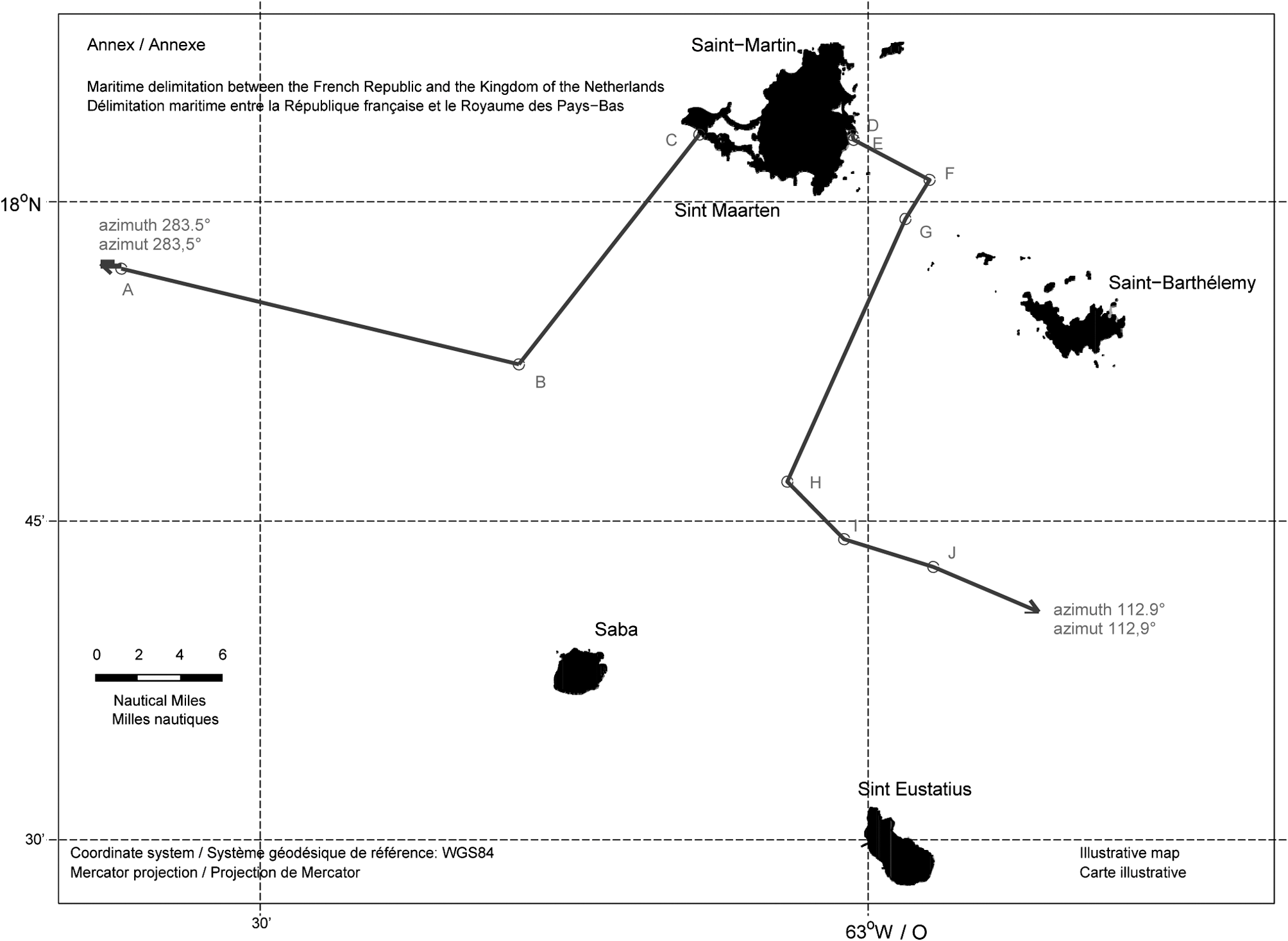
The western part of the maritime delimitation is formed by a geodesic line joining, in the order in which they are given, the following points identified by their geographical coordinates:
|
Point |
Latitude (North) |
Longitude (West) |
|---|---|---|
|
A |
17° 56’ 52” |
063° 36’ 51” |
|
B |
17° 52’ 22” |
063° 17’ 14” |
|
C |
18° 03’ 10” |
063° 08’ 20” |
From point A, the delimitation extends along a geodetic azimuth of 283,5 degrees until the delimitation with the United Kingdom of Great Britain and Northern Ireland is reached.
The eastern part of the maritime delimitation is formed by a geodesic line joining, in the order in which they are given, the following points identified by their geographical coordinates:
|
Point |
Latitude (North) |
Longitude (West) |
|---|---|---|
|
D |
18° 03’ 08” |
063° 00’ 46” |
|
E |
18° 02’ 55” |
063° 00’ 43” |
|
F |
18° 01’ 02” |
062° 56’ 58” |
|
G |
17° 59’ 12” |
062° 58’ 10” |
|
H |
17° 46’ 51” |
063° 03’ 59” |
|
I |
17° 44’ 09” |
063° 01’ 11” |
|
J |
17° 42’ 51” |
062° 56’ 47” |
From point J, the delimitation extends along a geodetic azimuth of 112,9 degrees until the delimitation with the Federation of Saint Christopher and Nevis is reached.
The delimitation line as established in articles 3 and 4 is drawn by way of illustration on the map in the Annex to this Agreement.
IN WITNESS WHEREOF the undersigned, duly authorised by their respective Governments, have signed this Agreement.
DONE at Philipsburg, on April 6th, 2016, in the English and French language, both texts being equally authentic.
Le gouvernement du Royaume des Pays-Bas
et
le gouvernement de la République française,
ci-après désignés « les Parties »,
Considérant qu’il est souhaitable de délimiter les espaces maritimes dans la région des Caraïbes sur lesquels les deux Etats exercent respectivement leur souveraineté, leurs droits souverains ou de juridiction,
Considérant que les relations entre le Royaume des Pays-Bas et la République française dans la région des Caraïbes sont fondées sur le principe de bon voisinage,
Se référant au traité de Concordia (Saint-Martin) conclu le 23 mars 1648,
Se référant à la Convention des Nations Unies sur le droit de la mer, faite à Montego Bay le 10 décembre 1982, à laquelle le Royaume des Pays-Bas et la République française sont parties,
sont convenus de ce qui suit :
1. La délimitation maritime entre le Royaume des Pays-Bas (le pays autonome de Sint Maarten, les entités publiques de Saba et de Saint-Eustache) et la République française établie dans le présent Accord est la délimitation des espaces maritimes sur lesquels les deux Etats exercent ou exerceront leur souveraineté, leurs droits souverains ou de juridiction.
2. Si une Partie décide d’établir, d’étendre ou de modifier des espaces maritimes, elle ne peut le faire que dans le respect de la délimitation maritime fixée dans le présent Accord.
Les coordonnées géographiques des points agréés dans le présent Accord sont exprimées dans le système géodésique de référence WGS 84 (World Geodetic System 1984).
La partie occidentale de la délimitation maritime est une ligne géodésique qui relie les points suivants exprimés par leurs coordonnées géographiques, dans l’ordre ci-après :
|
Point |
Latitude (Nord) |
Longitude (Ouest) |
|---|---|---|
|
A |
17° 56’ 52” |
063° 36’ 51” |
|
B |
17° 52’ 22” |
063° 17’ 14” |
|
C |
18° 03’ 10” |
063° 08’ 20” |
A partir du point A, la délimitation est une ligne géodésique d’azimut 283,5 degrés jusqu’à ce qu’elle atteigne la délimitation avec le Royaume-Uni de Grande Bretagne et d’Irlande du Nord.
La partie orientale de la délimitation maritime est une ligne géodésique qui relie les points suivants exprimés par leurs coordonnées géographiques, dans l’ordre ci-après :
|
Point |
Latitude (Nord) |
Longitude (Ouest) |
|---|---|---|
|
D |
18° 03’ 08” |
063° 00’ 46” |
|
E |
18° 02’ 55” |
063° 00’ 43” |
|
F |
18° 01’ 02” |
062° 56’ 58” |
|
G |
17° 59’ 12” |
062° 58’ 10” |
|
H |
17° 46’ 51” |
063° 03’ 59” |
|
I |
17° 44’ 09” |
063° 01’ 11” |
|
J |
17° 42’ 51” |
062° 56’ 47” |
A partir du point J, la délimitation est une ligne géodésique d’azimut 112,9 degrés jusqu’à ce qu’elle atteigne la délimitation avec la Fédération de Saint-Christophe-et-Niévès.
La ligne de délimitation maritime telle que définie aux articles 3 et 4 du présent Accord est représentée aux fins d’illustration sur la carte annexée au présent Accord.
EN FOI DE QUOI, les signataires, dûment mandatés par leurs gouvernements respectifs, ont signé le présent Accord.
FAIT à Philipsburg, le 6 avril 2016, en langues anglaise et française, les deux textes faisant également foi.
Het Verdrag, met Bijlage, behoeft ingevolge artikel 91 van de Grondwet de goedkeuring van de Staten-Generaal, alvorens het Koninkrijk aan het Verdrag, met Bijlage, kan worden gebonden.
De bepalingen van het Verdrag, met Bijlage, zullen ingevolge artikel 7 van het Verdrag in werking treden op de eerste dag van de tweede maand na de datum van ontvangst van de laatste schriftelijke kennisgeving van partijen dat de onderscheiden nationale procedures die vereist zijn voor de inwerkingtreding van het Verdrag, met Bijlage, zijn voltooid.
|
Titel |
: |
Verdrag van de Verenigde Naties inzake het recht van de zee; Montego Bay, 10 december 1982 |
|
Tekst |
: |
Trb. 1983, 83 (Engels en Frans) Trb. 1984, 55 (vertaling) |
|
Laatste Trb. |
: |
Uitgegeven de negenentwintigste april 2016.
De Minister van Buitenlandse Zaken, A.G. KOENDERS
Kopieer de link naar uw clipboard
https://zoek.officielebekendmakingen.nl/trb-2016-52.html
De hier aangeboden pdf-bestanden van het Staatsblad, Staatscourant, Tractatenblad, provinciaal blad, gemeenteblad, waterschapsblad en blad gemeenschappelijke regeling vormen de formele bekendmakingen in de zin van de Bekendmakingswet en de Rijkswet goedkeuring en bekendmaking verdragen voor zover ze na 1 juli 2009 zijn uitgegeven. Voor pdf-publicaties van vóór deze datum geldt dat alleen de in papieren vorm uitgegeven bladen formele status hebben; de hier aangeboden elektronische versies daarvan worden bij wijze van service aangeboden.